Drone Mapping Services for Surveying Professionals

FAA Part 107 pilots · Insured

Get a project estimate

Why outsource to Stratus Imaging?

Most survey firms we work with already know what drone data can do—they are deciding who should fly, process, and document it. We act as your UAS and photogrammetry subcontractor: you get orthomosaics, surfaces, contours, point clouds, and quality reporting on a predictable timeline, while your team stays focused on survey work only you can sign off on.

Typical turnaround: deliverables within 3 business days after we are on site and have completed the flight, unless we agree otherwise for your scope or schedule.

Ground control—your workflow

If you want tight control end to end, you set and survey your own GCPs and checkpoints—we build the deliverables to your control. If you want less effort on your side, we can place and survey aerial targets within control you have already established, under your direction and review. In every case, the examples and metrics on this page are for your professional evaluation.

Methods & Standards

Standard Deliverables

  • Georeferenced orthomosaics (GeoTIFF)
  • Digital Surface Models (DSMs)
  • Digital Terrain Models (DTMs)
  • Contour lines (DXF, Shapefile)
  • TIN surfaces (LandXML, DXF)
  • Point clouds (LAS, PLY formats)
  • Quality reports with accuracy metrics

Equipment & Processing

  • RTK-Enabled Drones: DJI M3E with centimeter-level GPS accuracy
  • Ground control: Your GCPs/checkpoints, or we place targets tied to your existing control—per project
  • Checkpoint Validation: Independent accuracy verification points
  • Processing Software: Pix4D photogrammetry software
  • Coordinate Systems: NAD83, UTM, State Plane, and custom systems supported

Project Portfolio

The following projects demonstrate our data collection and processing capabilities. All accuracy metrics are provided for your professional evaluation. This represents a selection of recent projects and is not a comprehensive portfolio of all completed work.

Sandia Crest Project

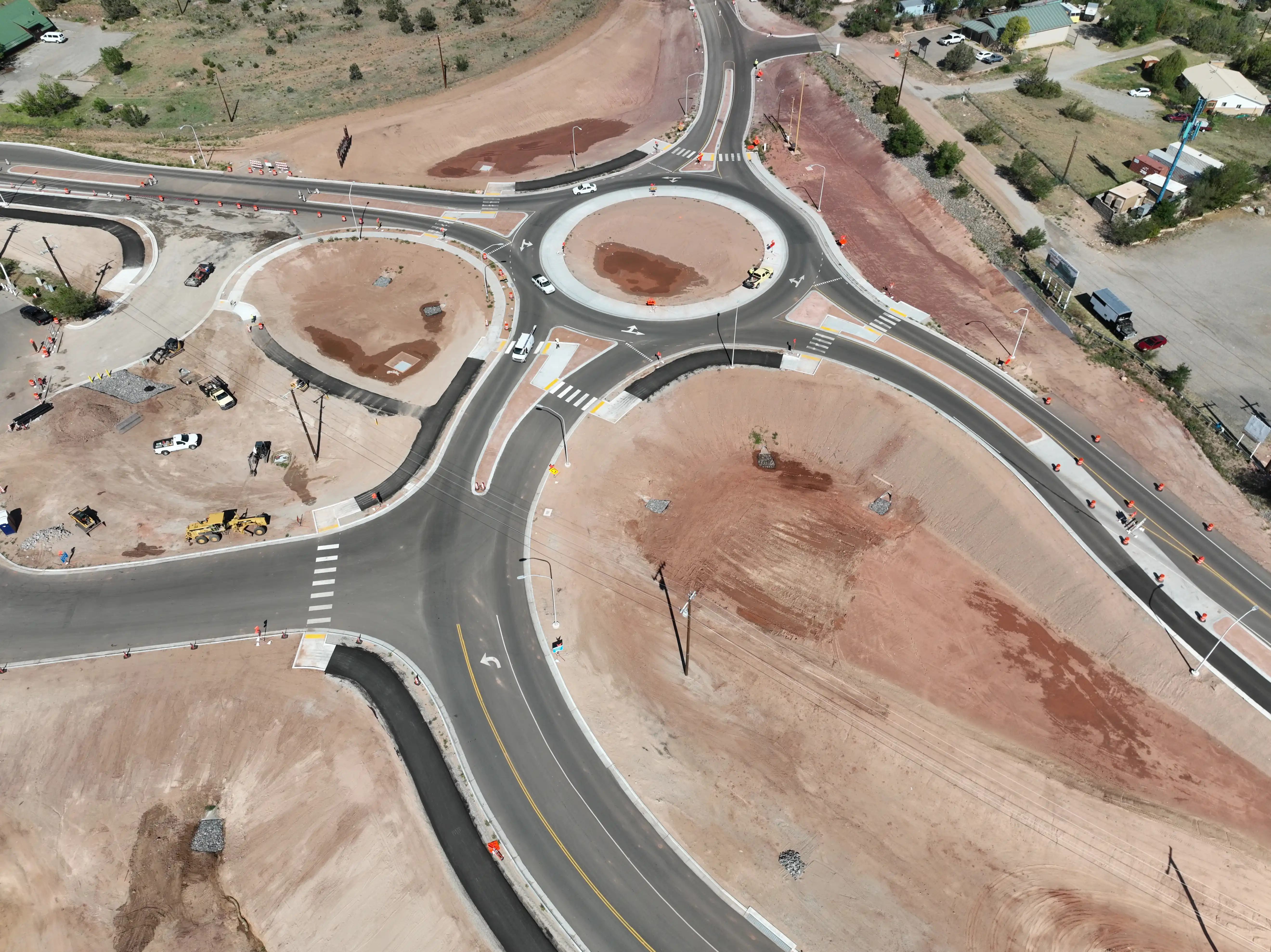
Sandia Crest Traffic Circle

Location: Sandia Crest, New Mexico | Date: September 2025

Project Specifications

  • GSD: 0.079 ft (2.4 cm/pixel)
  • Images Processed: 334
  • Camera: DJI M3E (12.3MP)
  • Coordinate System: NAD83 / New Mexico Central (ftUS)

Accuracy Results

GCPs: 8 points

Checkpoints: 7 points | RMSE: 0.211 ft (6.4 cm)

Component RMSE: X=0.063 ft, Y=0.069 ft, Z=0.189 ft

View Quality Report
Corona Highway Project

Corona Highway Project

Location: Corona, New Mexico | Date: September 26, 2025

Project Specifications

  • GSD: 0.088 ft (2.7 cm/pixel)
  • Corridor Length: 5 Miles
  • Images Processed: 1,304
  • Camera: DJI M3E (12.3MP)
  • Coordinate System: NAD83 / New Mexico Central (ftUS) + NAVD88 height (ftUS)

Accuracy Results

GCPs: 42 points

Checkpoints: 10 points | RMSE: 0.302 ft (9.2 cm)

Component RMSE: X=0.078 ft, Y=0.058 ft, Z=0.287 ft

View Quality Report
Tres Piedras Project

Tres Piedras Highway Project

Location: Tres Piedras, New Mexico | Date: October 8, 2025

Project Specifications

  • GSD: 0.087 ft (2.7 cm/pixel)
  • Corridor Length: 6.5 Miles
  • Images Processed: 1,658
  • Camera: DJI M3E (12.3MP)
  • Coordinate System: NAD83 / New Mexico Central (ftUS) + NAVD88 height (ftUS)

Accuracy Results

GCPs: 71 points

Checkpoints: 17 points | RMSE: 0.329 ft (10.0 cm)

Component RMSE: X=0.061 ft, Y=0.073 ft, Z=0.315 ft

View Quality Report
RTK-Only Sandia Crest Project

Sandia Crest RTK-Only Project

Location: Sandia Crest, New Mexico | Date: September 2025

Project Specifications

  • GSD: 0.079 ft (2.4 cm/pixel)
  • Images Processed: 334
  • Camera: DJI M3E (12.3MP)
  • Coordinate System: NAD83 / New Mexico Central (ftUS)

Accuracy Results

Method: RTK-Only (No GCPs)

Checkpoints: 11 points | RMSE: 0.738 ft (22.5 cm)

Component RMSE: X=0.142 ft, Y=0.688 ft, Z=0.227 ft

Note: RTK-only processing suitable for shorter baselines and projects where sub-0.1 ft accuracy is not required. Provides cost-effective solution for smaller projects.

View Quality Report

Ready to Discuss Your Project?

For a rough estimate first, use our project pricing calculator. For scope, deliverables, or scheduling, contact us—we’ll align on accuracy targets, coordinate systems, and ground control with your team.

Phone: (505) 550-7340

Email: info@stratus-imaging.com

Pricing calculator Request quote

Professional Considerations

  • All data provided for your professional evaluation
  • We are not licensed land surveyors. We capture aerial data and produce photogrammetry outputs to support your surveying work.
  • You (the contracting PLS) control project requirements and issue any sealed survey deliverables as needed.
  • Custom accuracy requirements can be discussed
  • Coordinate systems can be specified per project needs